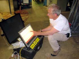
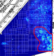
Untitled Document


Concrete and Soil Imaging
for Forensic Engineering
 

Untitled Document
Home Page
SERVICES
Ground Penetrating Radar
Surface Penetrating Radar
Soil Mapping
Digital Scan Analysis
CUSTOMERS
Engineers
Architects
Construction
Contractors
Academic & Universities
Hospitals & Health Care
Municipalities / Government
Golf Courses
Agricultural
Cemeteries
ABOUT PEGASUS EC

Company Information


Untitled Document

Cage Code: 4H6E8

NAICS Codes & Classifications (NAICS)

541360 Geophysical Surveying and Mapping Services
541380 Testing Laboratories
541420 Industrial Design Services
541620 Environmental Consulting Services
541710 Research/Development in Physical, Engineering & Life Sciences

Standard Industrial Classification (SIC)

8731 Commercial Physical Research
8734 Testing Laboratories

Product Service Codes (PSC)

AA10 R&D - Insect & Disease Control
B510 Study/Environmental Assessment
F018 Other Range/Forest Improvements
F021 Site Preparation
R510 Study/Environmental Assessment
T009 Photographic - Aerial
T099 Other Photo Mapping Printing
Y211 Construct/ Dams
Y215 Construct/ Surface Mine Reclamation
Y300 Construct/ Restoration

Capabilities:

  • Vegetative Assessment
  • Utility Locating
  • Concrete integrity
  • Pavement integrity
  • Soil Mapping
  • Geological Survey
  • Soil 3-Dimensional Profiles


Untitled Document
Pegasus Environmental GPR images

State-of-the-Art Data Analysis

Pegasus Environmental Knows that our success depends entirely on providing you with accurate, easy to understand analysis after we have provided GPR scanning services. We take great pride in in our ability to share findings pictorially, with a written report filed electronically, and upon request, a presentation with a PowerPoint slide show.

As we are fond of saying, "You may not care what kind of watch we have, you just want to know what time it is."

That said, we use the finest Non-Destructive Testing equipment available for scanning, with an accuracy tolerance finer than than one inch. The scanner is connected electronically to a computer, which provides on-site spectral analysis, which is stored as a series of graphics files. We can peel layers from these files, like an onion, to show specific depths in one inch increments.

Our reporting is customized to show these results in significant detail. Also, we use paper grids that can be left in place and marked to show precise locations for safe digging and excavation.


Pegasus Environmental Co., P.O. Box 4, Spencerport, N.Y. (585) 278-0103
Powered By: Gleason PR